jeffwongdesign

~1 Year Since My Bike Accident

Photos of my bike with an updated Surly touring frame.

I can’t believe it’s been about a year since my bike accident last year. For those of you who don’t know, around this time last year, I got in a nasty bike accident last year which left me with stitches, a concussion, two chipped teeth, and a damaged bike. It was pretty rough because it overlapped the time when I was shutting down Flare and transitioning to a new project. Thankfully, I had insurance and a strong support network here to help me out.

I made a fast recovery… and when I was able to ride again, I made a video that documented my crash as well as an issue I had with my bike. This all happened last year, but I’m finally getting around to sharing this video one year later.

One of my first vlogs on youtube I created last year.

Anyway, everything is okay now. Since then, I get my bike serviced once a month to make sure all the parts are in working order. I also got a full face helmet along with a GoPro to document my daily commute.

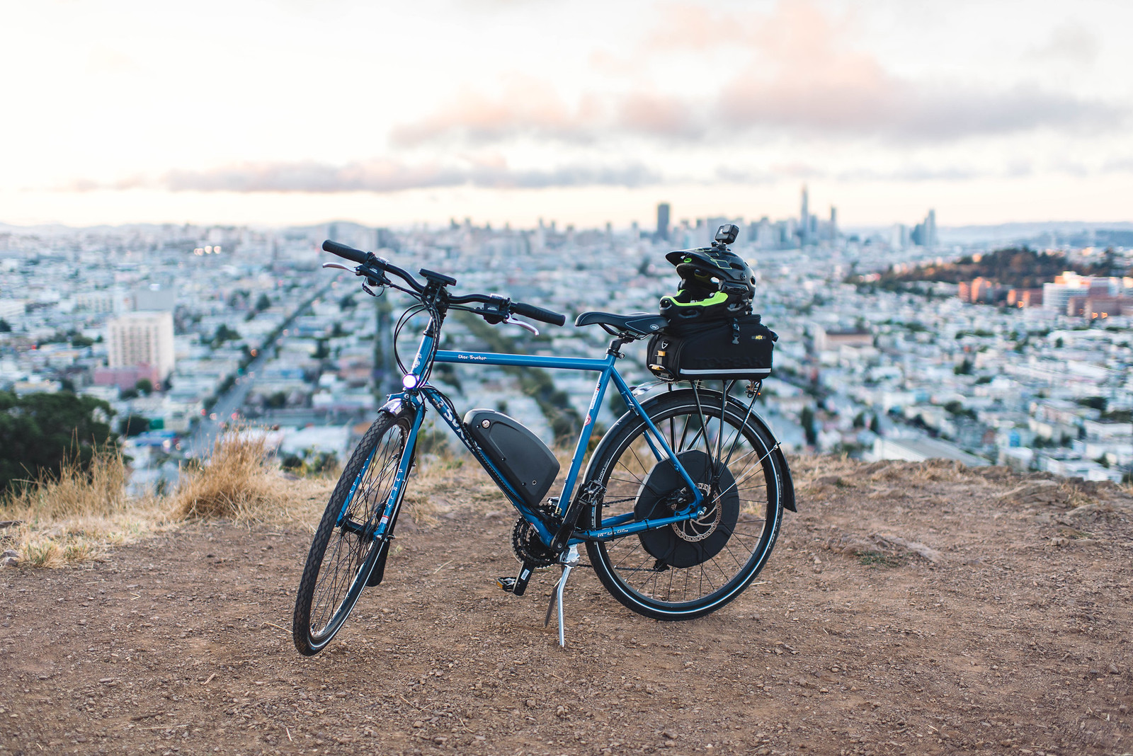
By the way, since last year, New Wheel (the company that sold me my e-bike), replaced my damaged frame free of charge. I had to twist their arm, but they stood by their product and rebuilt my bike after the rear wheel dislodging. So, if you’re in the market to get an electric bike in San Francisco, I’d recommend them.

So, I ride super conservatively now and I avoid questionable conditions.

HOWEVER, Google Maps managed to navigate me through a really sketchy path. I would say this felt as sketchy as walking around in the Tenderloin at night. I really wish there was a checkbox on Google Maps that says, “Avoid Sketch AF Routes”. Since I’m sharing some crazy videos, here’s another one…

Sketch AF bike route by Google Maps.

#neveragain

While I love San Francisco, there are times that I’d like to get away from the craziness. I live in Bernal Heights now, and it’s pretty safe/clean… but all you have to do is walk a couple streets down the hill, and it gets seedy.

Okay to lighten things up, here’s one more video of another bike ride. This is a time lapse of a bike ride I did with Patrick from Sausalito back to Bernal Heights.

Timelapse video of a 56 mile bike ride from Sausalito to Bernal Heights.

Hopefully you won’t get too dizzy watching it. It kind of starts smoothing out once we go over the Golden Gate bridge. Next time I’ll see if I can run these kinds of videos through a hyper lapse filter to remove all the jittering. Enjoy!

Photos from My Bike Ride

DSC_8183

Photo of a blocked off road beside Ocean Beach in San Francisco.

After the storm cleared up this morning, I decided to go for a bike ride. I ended up doing a 25 mile loop around the city. Here are some photos from my ride.

DSC_8182

Crossing the road.

DSC_8153

Shadows and pruned trees in the city.

DSC_8160

Stairs near the Painted Ladies.

DSC_8167

A small beach between Lands End and Presidio.

DSC_8170

Museum at the top of Lands End, featuring a collection of work by Monet.

DSC_8173

Photo riding down Ocean Drive.

DSC_8189

Close up photo of flowers in Golden Gate Park.

DSC_8179

Ocean beach.

DSC_8190

The court yard between the California Academy of Sciences and de Young Museum.

Helping Sol Move

IMG 0270

Photo of Sol and Mochi exhausted after moving his furniture from one apartment to another.

This past weekend I helped Sol move. He doesn’t have that much stuff, but it’s crazy to see how much energy it takes to move just a few things. Moving is a bitch. Hah!

IMG 0271

Sol’s new apartment.

Sol’s new apartment is pretty nice—it’s got plenty of natural light, an open space, and a small balcony. I’m really happy for him. He got a great deal, and think he needed to change things up a little.

New Bike and First Ride to Sausalito California

IMG 0277

Photo of my new bike, Evo HB1 Disc, using a Bionx D500.

I took my e-bike out for a 40 mile ride yesterday around San Francisco and Sausalito. I’m happy to say that the bike had just enough juice to get me there and back.

IMG 0284

I think if my ride had no stops, I could have easily gotten 50 miles out of the battery. On the other hand, if I maxed out the electic assist, I probably would have only gotten 25 miles.

IMG 0280

Screenshot of the path I took from Bernal Heights to Sausalito.

Truth be told, I actually made my way up to Mill Valley (a couple miles north of Sausalito). I always wanted to check out some of the scenic paths in Richardson Bay.

IMG 0288

The tidal action of Richardson Bay is very important to the plants and animals that live in and around the bay shore. The profile of the shoreline can be divided into zones that are affected by different tidal heights. Plants and animals that can surviv for longer periods of time exposed to air, wind and sunlight are located at higher elevations. Others must live at lower elevations where they will be covered by water for longer periods of time. The birds that rely on the bay shore for their food and shelter are also influenced by the effects of the tides. Each bird has adapted its foraging technique to the particular kinds of food that it eats. Some ducks dive for fish, others dabble for algae and invertebrate. Many shore birds have long legs and long beaks to probe the mud in shallow water, while others have short legs and short beaks and look for food along the tide line.

IMG 0289

Photo of the sun setting over San Francisco Maritime National Historical Park.

IMG 0290

Photo of my e-bike’s computer, showing 40.1 miles travelled, with little battery remaining.

Good thing I had just enough juice to get home. Whew.

IMG 0287

Photo of my e-bike in Sol’s lobby.

On a side note, I’ve been commuting with an e-bike for the last week, and it’s been a great experience. No more sitting with homeless people in public transportation or incompetent uber pool drivers. Okay, that’s a generalization, but I’ve come to a conclusion that it’s way more enjoyable to commute via bike.

Tartine Bakery & Cafe

DSC_3553

Fresh pastries at Tartine.

After Coit Tower, we grabbed some lunch at Tartine Bakery & Cafe.

Pastry chef ELISABETH PRUEITT and her husband, renowned baker CHAD ROBERTSON, are the co-owners of Tartine Bakery and Bar Tartine in San Francisco. They both trained at the Culinary Institute of America in New York. Elisabeth and Chad traveled, trained, and cooked in France and upon their return, opened Bay Village Bakery in Point Reyes Station, California. Using a wood fired brick oven, they baked bread and created rustic, elegant pastries using many of the techniques they had learned abroad. Chad’s bread garnered the attention of Alain Ducasse, who wrote about the couple in his book, Harvesting Excellence.

I’d say that their pastries are pretty good. Their sandwiches are hella expensive. Be prepared to pay $17 for a sandwich. Annie said their breakfast bun was off the hook, so put your $$ towards their pastries.

DSC_3549

More deliciousness.

DSC_3554

Expensive cookies. $10.50 per bag.

I would say that the food was good, but probably overpriced for my liking. Other than that, their pastries are fantastic.

DSC_3553

More pastries.

DSC_3547

Julia walking into Tartine.

Coit Tower

DSC_3542

Photo of Coit Tower from the parking lot.

After driving around Golden Gate Bridge, we headed to Coit Tower.

The tower, in the city’s Pioneer Park, was built in 1933 using Lillie Hitchcock Coit’s bequest to beautify the city of San Francisco; at her death in 1929 Coit left one-third of her estate to the city for civic beautification. –Wikipedia

After living a year and a half in San Francisco, this was the first time I saw this landmark. While the parking lot of Coit Tower isn’t that scenic, the history is pretty interesting. I’m sure if you can go to top of the tower, the view is probably spectacular… perhaps that’s something I’ll have to do another day.

DSC_3541

Statue of Christopher Columbus, in front of Coit Tower.

Coit Tower was paid for with money left by Lillie Hitchcock Coit, a wealthy socialite who loved to chase fires in the early days of the city’s history. Before December 1866, there was no city fire department, and fires in the city, which broke out regularly in the wooden buildings, were extinguished by several volunteer fire companies.

I didn’t have a chance to go up the tower, but it was nice to quickly scope out the base and learn a little about the significance the tower.

DSC_3539

View from the base of Coit Tower, facing the Golden Gate Bridge.

Lillie Coit was one of the more eccentric characters in the history of North Beach and Telegraph Hill, smoking cigars and wearing trousers long before it was socially acceptable for women to do so. She was an avid gambler and often dressed like a man in order to gamble in the males-only establishments that dotted North Beach.

DSC_3546

The round about at Cost Tower, with little to no parking.

I’ll probably have to come back here at night—I’m sure the lighting is probably way more interesting.